A Spectacle From Space: NASA Satellite Captures Pacific Herring Spawn Turning Coastal Waters Turquoise
VANCOUVER ISLAND, British Columbia — Each spring, a remarkable natural phenomenon unfolds in the shallow coastal waters off western Canada. Thousands upon thousands of Pacific herring—small, silvery fish that form the backbone of the region’s marine food web—congregate in sheltered bays and inlets to perform an ancient ritual of reproduction. The event is so massive that it changes the very color of the sea, transforming turquoise stretches of coastline into milky, clouded waters visible from hundreds of miles above.
On February 19, 2026, NASA’s Landsat 9 satellite captured exactly that: a breathtaking image of an active herring spawn in Barkley Sound, on the southwestern side of Vancouver Island, near Forbes Island. The photograph, released Friday by NASA’s Earth Observatory, shows a swirling expanse of pale green and turquoise water hugging the shoreline—a telltale sign of milt, the sperm-containing fluid released by male herring as females lay their eggs.
Global Markets Rebound as US-Iran Ceasefire Hopes Drive Oil Below $100, Gold Surges.
“Spawning season has sprung for Pacific herring,” NASA announced in a feature accompanying the image, noting that the event occurs annually from mid-February through early May. “Thousands of the small, silvery fish congregate in shallow coastal areas around Vancouver Island and create a spectacle sometimes visible to satellites.”
The Science of a Spawn: How Herring Paint the Ocean
The Pacific herring (Clupea pallasii) is a forage fish—a species that serves as a critical food source for larger predators, including salmon, whales, sea lions, eagles, and bears. Their annual spawn is one of the most important ecological events in the Northeast Pacific, and its timing and location can have cascading effects throughout the marine food web.
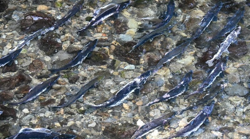
During spawning, female herring release eggs that adhere to a variety of underwater surfaces: kelp, seagrass, rocks, and even the hulls of boats. As the eggs are laid, males release milt into the water column, a process that can last from several hours to several days. The milt contains millions of sperm cells and gives the water its distinctive milky, turquoise hue—a color signature so pronounced that it can be detected by satellite sensors orbiting 438 miles above Earth.
The February 19 event near Forbes Island was no small affair. Local observers from the Island Marine Aquatic Working Group (IMAWG)—a collaborative organization that strengthens First Nations fisheries through traditional knowledge, modern science, and management guidance—reported that fish had begun staging in the area by February 13. Schools can arrive up to two weeks before spawning, according to Jessica Moffatt, a biologist with IMAWG. The actual spawning activity was reported from February 19 to February 21, with Landsat 9 capturing the event at its peak.
“Herrings prefer spawning locations that are more protected, have rocky substrate, and allow them to select areas with reduced salinity,” Moffatt explained in NASA’s feature. “Barkley Sound hits the sweet spot” in many of these regards, she said, adding that collective memory, predation pressure, and other factors also play a role in spawn size and location.
A Vital Resource: Cultural and Commercial Significance
For the First Nations peoples of British Columbia, herring and their roe have been a cornerstone of culture, diet, and trade for millennia. The fish are harvested not only for their flesh but also for their eggs, which are collected on kelp fronds—a delicacy known as “spawn-on-kelp” that is highly valued in traditional and contemporary Indigenous cuisine.
The commercial herring fishery in British Columbia is also economically significant, though it has been carefully managed in recent years due to conservation concerns. According to Fisheries and Oceans Canada (DFO), which maintains records of spawn activity dating back to the 1970s, spawns near Forbes Island have been observed most years for the past five decades.
The 2026 spawn appears to have been a healthy one. Ryan Cutler, a local photographer whose images accompanied NASA’s feature, captured stunning ground-level shots of milt-clouded waters and the frenetic activity of birds and marine mammals drawn to the feast. Along with changes in water color, spawns often bring increased wildlife presence: whales and sea lions swimming nearby, eagles soaring overhead, and wolves and bears lurking on shore, waiting to scavenge fish that die after spawning.
From Aerial Surveys to Orbital Eyes
Historically, monitoring herring spawns has been a labor-intensive process. DFO and other agencies have relied on aerial surveys, dive teams, and reports from remote locations to track when and where spawning occurs. These methods, while valuable, are limited in scope—they can cover only so much coastline, and they depend on the availability of personnel and favorable weather conditions.
But satellites are changing that. Landsat 9, a joint mission of NASA and the U.S. Geological Survey, has been orbiting Earth since 2021, capturing images of the planet’s surface in unprecedented detail. Its Operational Land Imager (OLI) can detect subtle changes in water color caused by sediment, algae blooms, and—as in this case—herring milt.
Oil Surges Past $115 as Middle East War Expands, Stocks Tumble Worldwide ‘A New Era of Cosmic Surveys’: NASA to Unveil Complete Roman Space Telescope Ahead of Fall Launch.
Researchers at the University of Victoria in Canada have been using decades of satellite observations to augment historical spawn records and develop automated methods to detect spawning events from space. Their work is part of a broader effort to understand how herring populations are responding to climate change, ocean acidification, and other environmental pressures.
“Observations by satellites, including Landsat, can help monitor herring activity over larger areas and longer periods of time,” NASA noted in its feature. The ability to track spawns from orbit offers scientists a powerful new tool for understanding the health of herring populations and, by extension, the entire marine ecosystem that depends on them.
A Fuller Picture of a Changing Ocean
Herring are what scientists call a “keystone species”—a organism whose presence and health have disproportionate effects on the entire ecosystem. As forage fish, they transfer energy from plankton (which they eat) to top predators (which eat them). When herring populations thrive, salmon thrive, and whales and sea lions have food. When herring decline, the effects ripple upward.
In recent decades, some herring populations along the West Coast have experienced dramatic fluctuations. The Sacramento River herring population in California, for example, collapsed in the 1990s and has never fully recovered. In British Columbia, management measures have helped stabilize some stocks, but uncertainties remain.
Understanding exactly where herring spawn—and whether those locations are changing over time—could provide crucial clues about shifts in the marine environment. Are herring spawning earlier or later as ocean temperatures rise? Are they abandoning traditional spawning grounds as coastal development or pollution increase? Are protected areas effectively safeguarding critical habitat?
“As a forage fish species, Pacific herring are vital to salmon and other marine life,” NASA’s feature noted, “and a fuller picture of the locations of spawning areas could provide clues about changes in the marine ecosystem.”
The View From Above and Below
The February 19 Landsat image is not the first time satellites have captured herring spawns from space. In May 2025, NASA’s Earth Observatory published a similar image of a spawn in the same region. But each year’s image adds to a growing archive of data that scientists can use to track trends over time.
For local observers like Moffatt and the volunteers of IMAWG, the satellite imagery complements the on-the-ground knowledge passed down through generations of First Nations fishers. Traditional ecological knowledge—observations of water color, wildlife behavior, and timing—has long guided Indigenous harvest practices. Now, that knowledge is being combined with orbital data to create a more complete picture of one of the Pacific coast’s most remarkable natural events.
“Herring spawn is a sign of spring,” Moffatt said. “It’s a time of renewal, not just for the herring but for the entire ecosystem. Seeing it from space just reminds us how big and how important this event really is.”
Looking Ahead: What the Spawn Tells Us
As the herring finish their spawning and return to deeper, nutrient-rich waters for the summer, the eggs left behind will hatch within two to three weeks. The larvae will drift with currents, feeding on plankton, and eventually grow into the next generation of fish that will—if all goes well—return to the same sheltered bays next spring to continue the cycle.

For now, the turquoise swirls captured by Landsat 9 serve as a vivid reminder of the intricate connections between land, sea, and sky. From the perspective of space, a fleeting biological event—lasting only days—becomes part of the permanent record, a data point in humanity’s ongoing effort to understand a changing planet.
“Spawning events last from several hours to several days,” NASA noted. “But the data they leave behind—captured by satellites—can help scientists understand these vital fish for years to come.”
SOURCES / INPUTS
https://science.nasa.gov/earth/earth-observatory/satellite-spots-a-spawn/
Climate Change Explained: Science, Global Policy, Economic Impact & Sustainability Strategy.
Flash Floods and Severe Weather Kill 17 Across Afghanistan, Destroy Hundreds of Homes, ‘Heading in the Wrong Direction’: UN Report Finds Nearly Half of Migratory Species in Decline Ahead of Global Wildlife Summit.